
by Lindsey Minges, Nigel Brown, Samantha Melvin,Matthew Bova, Nicholas Buccella
Faculty mentor: Dr. Jacqueline Gallagher
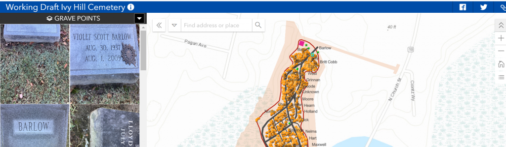
The Ivy Hill Cemetery Mapping project began during the Fall semester of 2019 and is still currently ongoing. The goal of this project is to create a searchable web app of the Ivy Hill Cemetery in Smithfield, VA of all the different graves located there, in addition to a cohesive story map that outlines the historic significance of the cemetery and town of Smithfield. Though the project is not yet complete, the work we have done thus far is a good indication of the trajectory of our project and what our finished product will look like. Whether for the purposes of genealogy research, data collection, or used as a tool to enhance the historic context of Smithfield, the final version of this project will be a comprehensive and readily available resource to the public.
This mapping project is an interdisciplinary approach to historic tourism by combining GIS/Geography and Historic Preservation to create a final product that is accessible to the public. To begin our project, we utilized a Trimble GPS with the ability to map locations within 4 inches of accuracy. Having access to this GPS allowed or group to map each individual grave and gravestone in the cemetery (upwards of 1500) and compile the data in ArcGIS Online and Pro software. We have combined this technology with historic preservation research approaches, working in tandem with representatives from the Isle of Wight County Historical Society to create an informative sense of historic context in relation to the cemetery.
Thus far, our group has completely mapped the Ivy Hill cemetery and transcribed each grave, and relevant information associated with it, into a comprehensive spreadsheet. Having all this data in one document allows us to easily edit the data to fit our mapping formats. Our next step in this project is to complete all our data edits as necessary and then join this data to create our finalized versions of the web app and story map. Currently, our group has created draft versions of these maps to better contextualize our final product. Once the project is complete, we will have created a searchable web app that allows the user to search for any defining grave characteristics (names, ages, dates, etc.) in the cemetery combined with a story map that outlines and contextualizes Ivy Hill as a historic feature in Smithfield, VA.
Group website: Ivy Hill Cemetary